
Rigas Autumn Legends rogaining
Agenda How to get there & Event centre Map
Legend on the dark ages and the renaissance of the grīziņkalns park
In 18th century the physician of the Queen Anna moved to Riga and in the middle of marshland on top of a sandy dune erected Grīzenbergs manor. In 20th century a park was established here. Workers living in these neighbourhoods gathered here for political and social rallies. The boys of the "Crow Street Republic" waged war against the "Tulian Empire" of the Rural Street (as described in the famous Latvian novel "Crow Street Republic" by Jānis Grīziņš). During the First World War all the buildings burned down except for the Gardener's House which still stands today and which allegedly was protected from fire by the dragon wood carvings. During the interwar independent Latvia the abandoned Grīziņkalns park was restored with a new open air theatre, rosarium, pools and playgrounds. At that time the park was frequented not only by leisure seekers, but also sappers for their military exercises and even nudists. After the global financial crisis the Grīziņkalns park resembled a ghetto: alcoholics, prostitutes, children without future. There is not other saviour than street sports! Thus the local enthusiast Raimonds Elbakjans gave birth to the street sports organisation "Ghetto Games".


race day agenda
 Add to Google Calendar or
 ![]() add to Apple calendar.
add to Apple calendar.

| Laiks | Activity |
|---|---|
| 09:30 | Registration open and maps available |
| 11:00 | Start for 6h rogaining (participants of the Rogaining hike can start the distance from 11:00 a.m. to 1:00 p.m.) |
| 11:30 | Start for 3h MTB rogaining |
| 12:00 | Start for 4h rogaining |
| 13:00 | Start for 2h (team) rogaining, 2h rogaining (solo) run and 2h rogaining walk (children) |
| 14:30 | Cut-off time for 3h MTB rogaining |
| 15:00 | Cut-off time for 2h (team) rogaining and 2h for rogaining (solo) run |
| 16:00 | Cut-off time for 4h rogaining |
| 17:00 | Cut-off time for 6h Rogaining and Rogaining hike |
| 17:10 | Award ceremony for all distances and INTERVALS.LV lottery with Garmin and other prizes begins |
Location and area of the event center
The event center will be located at "Ghetto Games" sports centre (Pērnavas iela 42, Riga, LV-1009)
Directions to the event centre: 

The limited parking is available in nearby streets. We suggest parking cars in nearby Daugavas stadium (Augšiela 1, Latgales priekšpilsēta, Rīga, LV-1009). The price for period 8.00 - 20.00 is 3 EUR.


GPS route RECORDING AND ANALYSIS
 If you want your fans to follow you during the competition on the big screen in the event center, or after the competition analyze your (or your competitors') blunders around the control point location - use the MapRun smartphone app:
- iPhone version: https://apps.apple.com/us/app/maprun/id1634949963
- Android version: https://play.google.com/store/search?q=maprun&c=apps
- Garmin version: https://apps.garmin.com/en-US/apps/05fa6a5e-e9e6-4865-8b3b-0b8a3c64eeba
- Open the application > Name > Write down your first name, last name, gender, age > Accept > Select Event > Latvia > Pilsetas_legendas > "Event name" (scan the šo QR code or click the link) > Ok (wait ~20 seconds until the files download to your phone) > Go to Start
- Turn on the GPS function on your smartphone shortly before the start.
- When you get within 15 meters of the start or control points or the finish line at the end, they will turn green (punched) and your smartphone will beep/vibrate (further on, you can keep your phone in your pocket or backpack without pulling it out until the finish line, because as long as you hear the phone beeping at each control point, it means that the application is working fine).
- You can also use your GPS watch instead of your phone and upload your recorded GPX route after the finish here: http://www.p.fne.com.au/#/gpsupload
- You can analyze your and competitors' routes here.
- If the MapRun application did not count a control point for you, then press: Show Results > select the rogaining you just ran > Review Results (HITMO) and indicate the missing checkpoints!
map legend
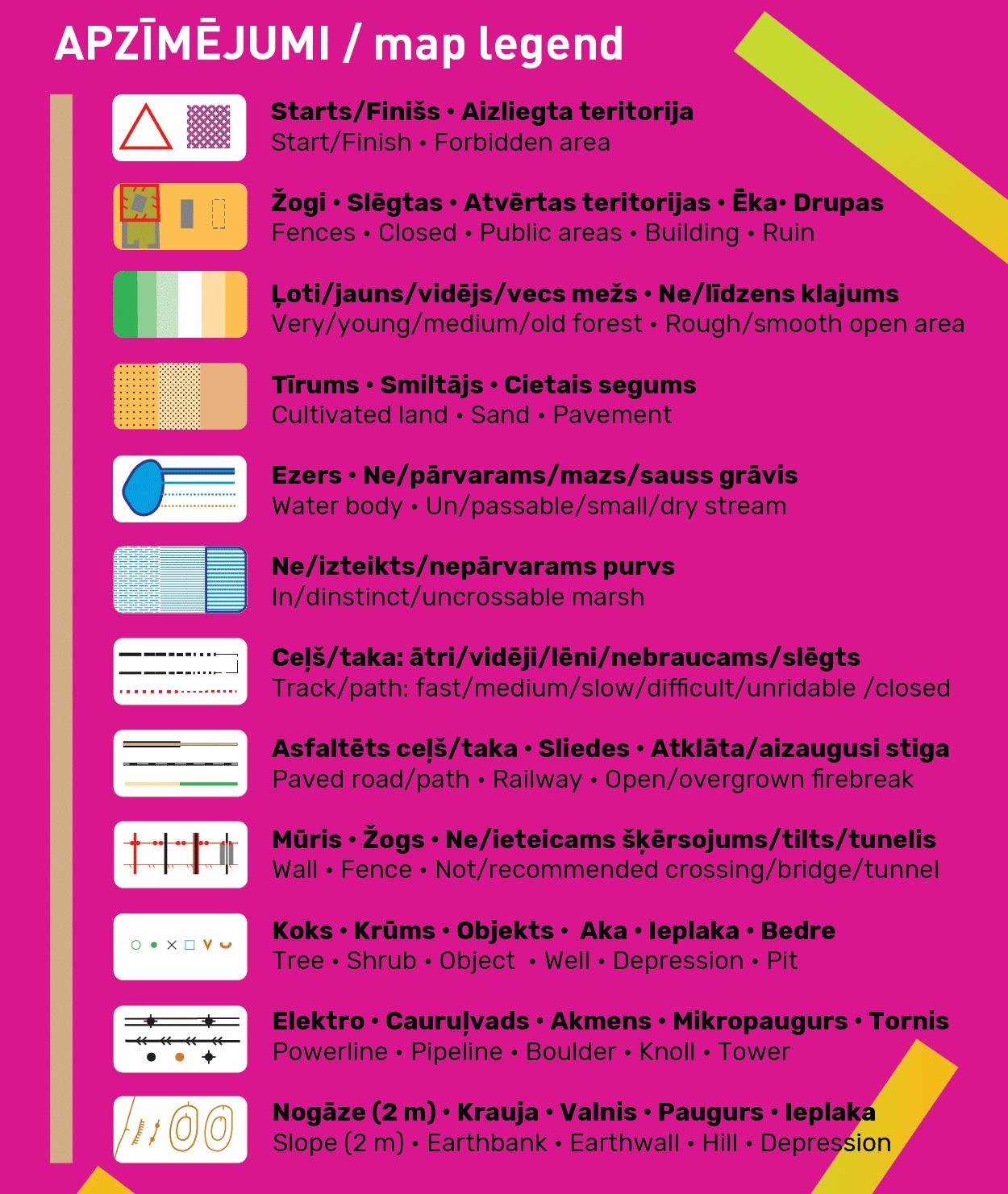 For the convenience of cyclists, the map will differentiate between paved (brown) and unpaved fast/medium/slow/very slow (the more dotted, the slower) black roads and trails. Tracks of tractors marked with the narrow firebreak line will be useless for cyclists, but pedestrians can still try to get through.
Vegetation is depicted as closely as possible to the gradual transitions observed in nature from very young to young, to medium, to old forest, using 4 different colors: green, lighter, very light and white, which is already used on orienteering sports maps. However in our case they will not display runability, but only the age/height of the forest. This is possible thanks to the laser point cloud data published by the Latvian Geospatial Information Agency, which everyone can download free of charge and generate map layers from them.
We remind you that the areas shaded with olive green in the standard orientation signs are closed to participants. On the other hand, we colored the closed roads in red color. Even if it is not marked on the map, but you see the sign "Private property" and "Entry prohibited" - please respect it and choose another way. Of course, first of all, the organizers will try to plan the control points to bypass such places and not to affect the rights of private owners.
The elevation contours will be depicted at a 2 m step.
race MAP AND TERRITORY
Participants will be handed maps in the morning of the competition when registering at the registration tent. The maps will be waterproof, but each participant is responsible for preserving the map in wet conditions. If you plan a very rough race and swimming - tape all four sides of the map. The scale of the map is 1:20,000 or 1 cm = 200 m in nature. Size 62 x 43 cm (take this into account when choosing a bike card holder).
control point legends
Get acquainted with control point legends (also known as location descriptions)! Although in any case you should look for an object located in the center of the circle, the legends explain more precisely whether you should look for the north or south side of the building, etc. Some of the locations of the checkpoints are too famous so that we had to encode them in order not to reveal them ahead of time. However you can try to decipher them even now. You will find out the correct answers on the day of the competition before the start, when you will receive your map with all the control points marked.